Environmental Sleuths Find Signs of Fracking
Online volunteers at the nonprofit SkyTruth scan aerial images for signs of oil and gas drilling.
By NICOLE WALLACE
Features Editor
March 1, 2015 | Read Time: 2 minutes
When SkyTruth set out to map hydraulic fracturing—the technique for drilling oil and gas better known as fracking—it tapped a cadre of dedicated online volunteers to review thousands of aerial photographs.
The West Virginia nonprofit, which uses remote imagery to study environmental issues, made its name during the 2010 Deep Horizon oil spill when it offered the first challenge to BP’s estimate of how much oil was gushing into the Gulf of Mexico.
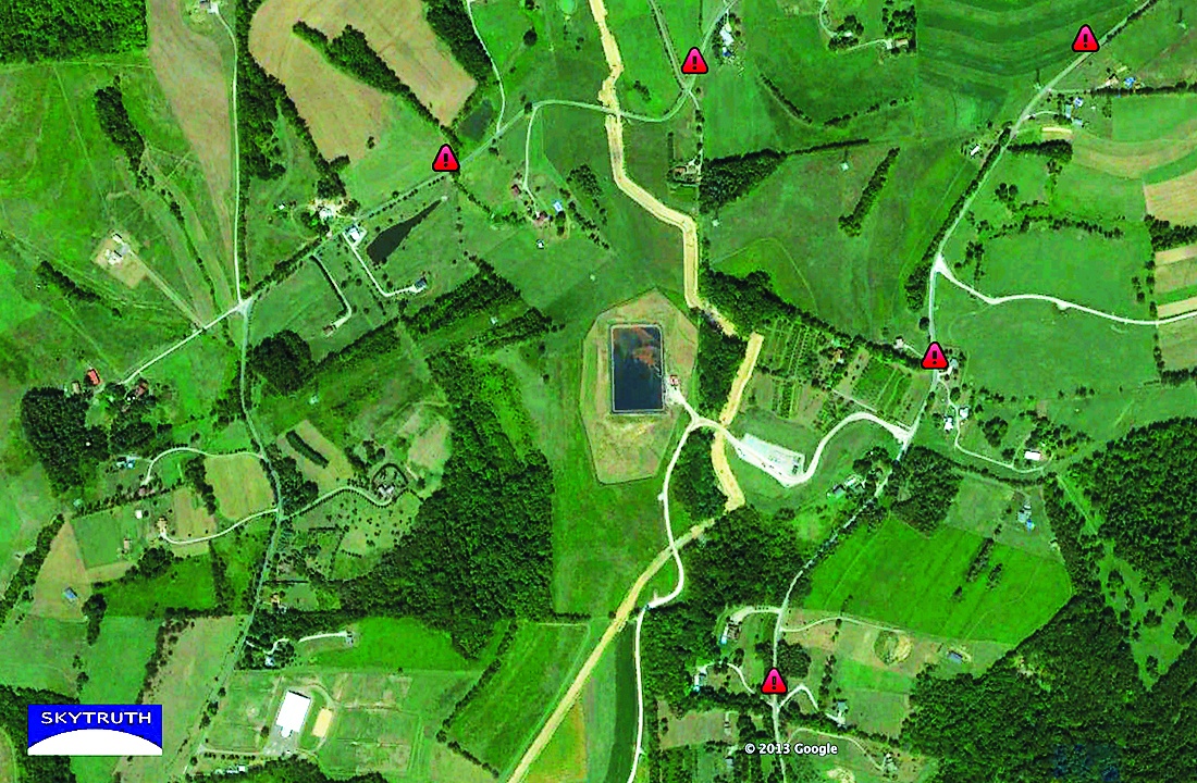
For its FrackFinder project, SkyTruth is recruiting volunteers to look at high-resolution remote photographs of sites that have obtained permits for oil and gas drilling. Volunteers mark whether they see drilling pads in the photographs.
Volunteers reviewed nearly 9,000 images as SkyTruth examined fracking in Pennsylvania.
To make sure that its assessments were accurate, each image was shown to 10 volunteers, and the group accepted their judgment only when at least eight of the volunteers came to the same conclusion. SkyTruth employees later analyzed the 10 percent of images where there was disagreement. Still, the 233 volunteers got through the entire set of images in 29 days.
One former Pennsylvanian living in Japan assessed more than 5,000 photos on the train going to and from work.
Looking for Health Risks
In a later project, volunteers reviewed remote images to identify man-made ponds built to hold the large amounts of wastewater generated by nearby fracking. The wastewater contains chemicals, and opponents worry that leaks from the ponds could contaminate nearby waterways and contribute to air pollution.
SkyTruth created the first publicly available map of the wastewater holding ponds. Researchers at Johns Hopkins University are using the data on the location of the ponds to study whether they pose a health risk to the public.
Crowdsourcing helped the organization analyze a huge volume of information, but it’s equally important as a way for volunteers to engage with SkyTruth’s mission, says David Manthos, the group’s communications director.
“If people see something that resonates with them about a place they care about, that impact may inspire them to take the next step,” he says.